| ● Rounds of slow-moving storms will continue this
afternoon/evening. Another round of thunderstorms
with heavy rainfall is expected overnight.
● Widespread additional rainfall amounts of 1-3” are
expected through Wednesday, with localized amounts
of 4-7+” possible.
● Locations that receive 1-2” of rain in a few hours will
be prone to flash flooding
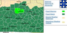
● The highest flooding risk will be across southern
Indiana & central Kentucky.
● Excessive runoff may result in flooding of creeks,
streams, and other low-lying flood-prone locations.
Low-water crossings may be flooded
○ Turn Around, Don’t Drown!! |